China’s 5 kHz Millimeter-Level Satellite Laser Ranging System Passes International Validation
Recently, a 5 kHz high-repetition-rate millimeter-precision satellite laser ranging (SLR) system led by the Shanghai Astronomical Observatory (SHAO), Chinese Academy of Sciences, in collaboration with Changchun University of Science and Technology, Shanghai University, and Beijing ShengLei Technology Co., Ltd., has achieved a significant leap in performance. The system is based on the 60 cm satellite laser telescope (Equipment No. 1000210171983016), a national platform-calibrated device at SHAO. The ground-target ranging accuracy has improved from the traditional 6–8 mm to 2–3 mm, with an annual average accuracy stabilized at 2.4 mm. The overall satellite ranging accuracy has increased from 6–10 mm to 2–4 mm, with the Beidou satellite in geosynchronous orbit achieving an accuracy of 1.9 mm. According to data evaluated by the International Laser Ranging Service (ILRS), the normal point accuracy for the international standard satellite Lageos reaches 0.9 mm, with short-term orbital stability of 5.8 mm and long-term stability of 2.1 mm. All indicators rank among the best internationally, positioning the comprehensive capability of the SLR station within the first echelon of global ILRS stations. This achievement, titled "High Data Quality, High-Precision Millimeter-Level 5 kHz Repetition-Rate Satellite Laser Ranging," will be published as a cover paper in the journal Reviews of Geophysics and Planetary Physics (Chinese/English), showcasing China’s major innovation in this field. The system’s key indicators are among the highest across ILRS stations worldwide and represent the best performance among domestic SLR systems, providing an effective approach for high-precision measurement of space targets.
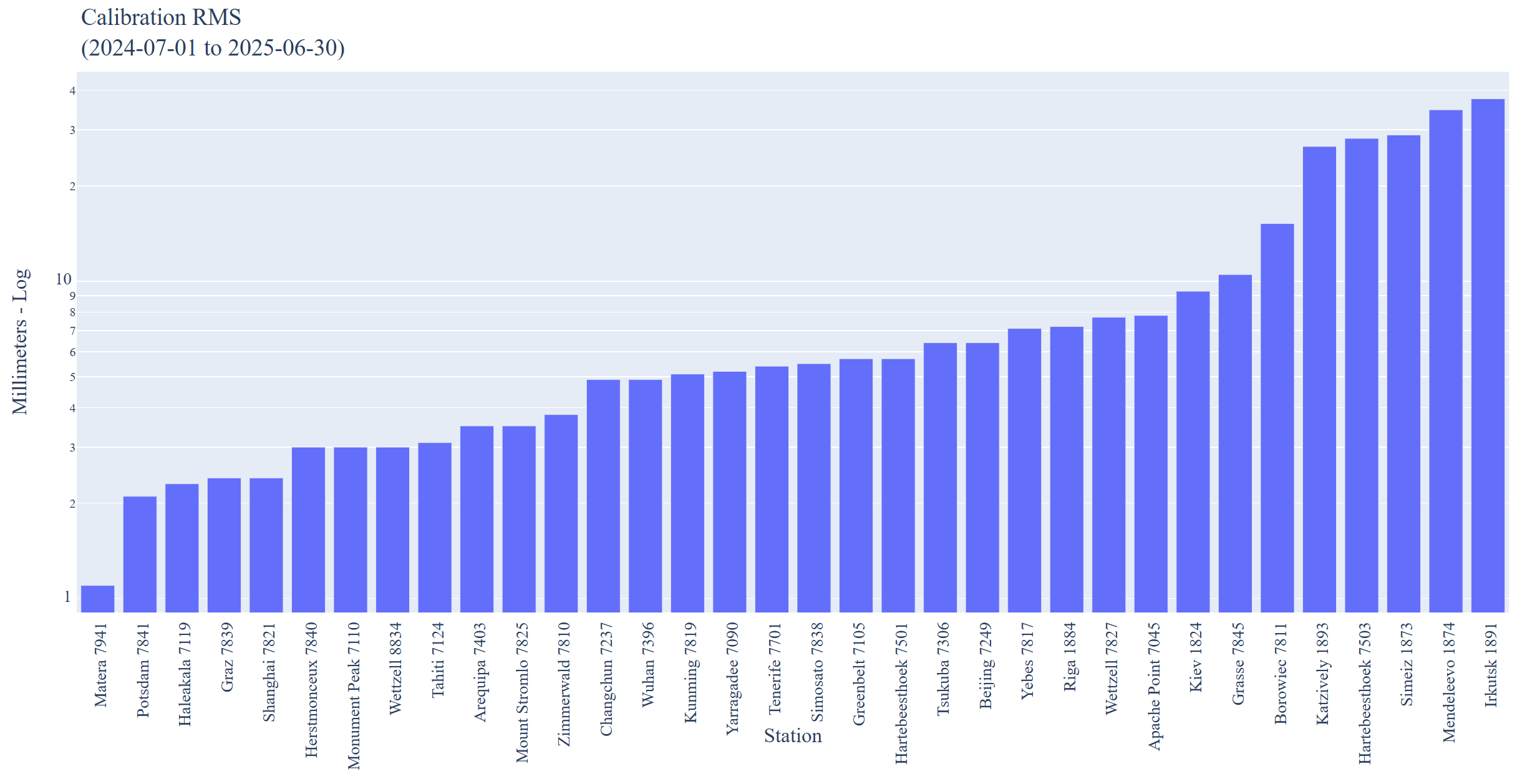 Global ILRS station calibration accuracy ranking—SHAO 2.5 mm, tied for fourth with Graz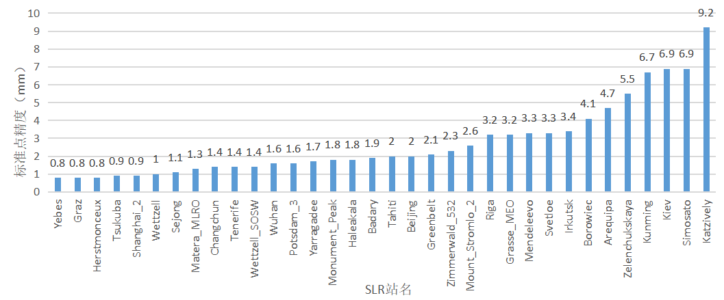
Global ILRS station normal point accuracy ranking for Lageos satellites—SHAO 0.9 mm, tied for second with Tsukuba
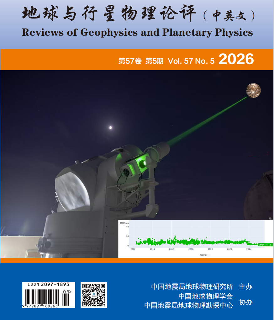
Physical effect of the 5 kHz satellite laser ranging system in nighttime operation, with the laser pointing at the spherical Lageos-1 satellite. Bottom right: Statistical graph of SHAO’s measurement accuracy over more than a decade (since 2012), showing improvement from centimeter level (~1 cm) to millimeter level (2–3 mm), with a system measurement accuracy of 2.1 mm in November 2024
Satellite laser ranging is currently the most accurate space geodetic technique worldwide. Its principle involves precisely measuring the round-trip time of a laser pulse emitted from a ground station to a satellite and back, thereby calculating the exact distance between the satellite and the ground station. After more than six decades of development, international SLR technology is rapidly advancing toward higher repetition rates, improved ranging accuracy, and all-weather stable observation. The SLR research team at SHAO systematically identified laser pulse width and single-photon detector timing jitter as the core bottlenecks limiting the improvement of ranging accuracy into the sub-millimeter to millimeter level. To address these challenges, the team carried out systematic optimization and upgrades, jointly developing a highly stable picosecond green laser with a narrow pulse width of 15 ps, significantly reducing the time measurement error introduced by the laser pulse. In addition, they selected MPD high-performance single-photon detectors and comprehensively improved the range gate circuit, event timer, and high-speed data acquisition system, ensuring stable, reliable, and uninterrupted day-and-night operation of the system at a 5 kHz repetition rate. This achievement not only consolidates China’s leading position in high-repetition-rate satellite laser ranging but also provides robust technical support for applications such as precise orbit determination of Beidou navigation satellites and fine-scale Earth dynamics observation. In the future, the research team will continue to advance system miniaturization and intelligent upgrades, expand into new applications such as deep-space laser ranging and high-precision measurement of space debris, further enhancing China’s technological competitiveness in global space geodesy and deepening the extension of these achievements.
ILRS: https://ilrs.cddis.eosdis.nasa.gov/network/system_performance/global_report_cards/monthly/2025/06/2025_06_Monthly_report_card.html
DOI: https://www.sjdz.org.cn/article/doi/10.19975/j.dqyxx.2025-033
Scientific contact: LONG Mingliang longmingliang@shao.ac.cn
Download attachments:




